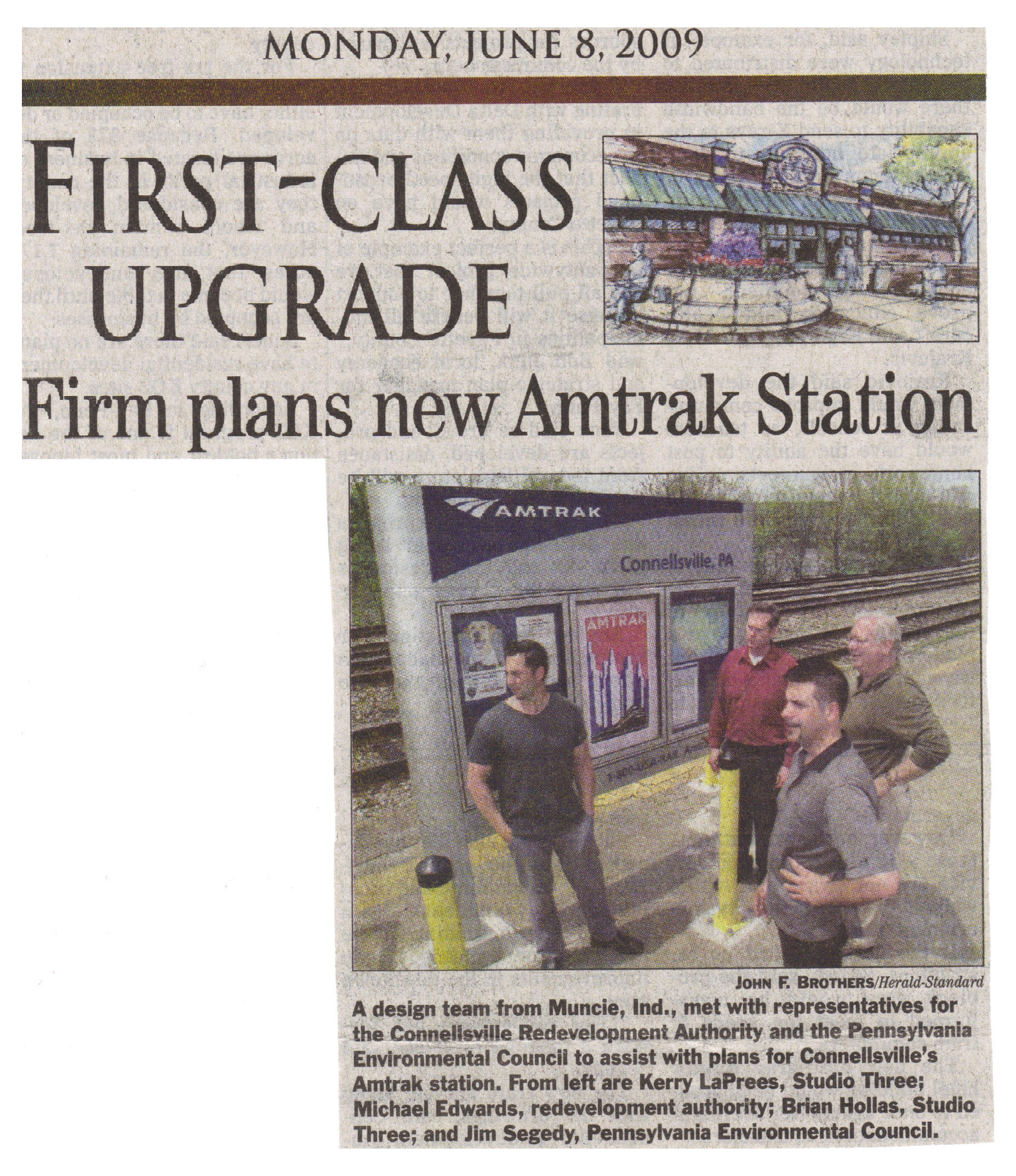
Amtrak In
Connellsville urged to upgrade with restrooms,
baggage checks
By
Jennifer Reeger
TRIBUNE-REVIEW
Saturday, June 13, 2009
Step off the Amtrak train in Connellsville and the area isn't very
inviting.
There's the drab glass and aluminum shelter station, a pay telephone and a
sign describing Amtrak's routes. There are seats in the musty shelter, but
no restrooms.
"Right now, you're let off in the middle of a train switching yard, and
you can't even see downtown from there, so they're lost and there's no one
or nothing there to help them," said Jim Segedy, director of community
planning for the Pennsylvania Environmental Council.
But
since Amtrak announced in April that it is updating the Connellsville
station with a new $1.25 million "retro-style" brick and stone shelter,
officials working on the city's revitalization efforts are hopeful that
more can be done to make the area welcoming to visitors.
And
they're trying to persuade Amtrak to build a station that allows for
checked baggage and has restrooms -- amenities that were left out of the
upgrade.
Karina Romero, a spokeswoman for Amtrak, said it will use federal stimulus
funds to build the new station as well as a 550-foot platform to bring
Connellsville up to compliance with the Americans with Disabilities Act.
The semi-enclosed station will have heating and benches, but it will not
have restrooms and will not offer checked baggage service --
something that
is lacking at the current structure.
Romero said Amtrak is updating several stations and will base the
amenities at each on the number of passengers utilizing the location.
About 4,500 passengers used Connellsville in 2008, she said.
She
said Connellsville's low passenger load does not allow for restrooms or
checked baggage, which would require staffing.
"However, if we increase ridership, and we see an increase in ridership,
it's always a possibility," Romero said.
Officials trying to boost tourism to Connellsville, particularly in light
of the Great Allegheny Passage biking and hiking trail that runs through
town, hope that they can convince Amtrak of that need.
Studio Three, a Muncie, Ind., architectural firm that had been studying
Connellsville's downtown area and how to best connect it with the trail,
agreed to come back and work on some ideas related to the new train
station.
"It's just been shown that economic development has always centered around
train stations," said J. Michael Edwards, executive director of the
Connellsville Redevelopment Authority. "Being able to tie the train
station to our downtown, we think, is integral to our revitalization that
we have going on. We're really looking forward to seeing the suggestions
the team is going to come up with."
Segedy, whose group has taken the lead on developing the design vision for
Connellsville, said those suggestions will allow officials to go to Amtrak
with their hopes and concerns.
"They're just doing the bare bones, what they think they need," Segedy
said of Amtrak. "We're saying, 'Here is a potential to take it a step
further so you can handle baggage and bicycles and things like that,
because that's so critical to the access to the Great Allegheny Passage.'"
The
closest stations to Connellsville with checked baggage service, which
includes bicycles, are Pittsburgh and Cumberland, Md., Segedy said.
Allowing bicyclists to get off the train in Connellsville would make the
city more of a hub for their activity.
The
hope is to have public restrooms and signs that direct people to the
downtown area a few blocks away as well as to the trail.
Edwards said a farmers market or artisans market that coincided with the
train's arrival just after 7 a.m. each morning would be a nice way to
welcome people to the city.
Passengers who were waiting for the train heading to Washington Friday
morning said they would welcome a new station.
"It's kind of easy to see why they're going to upgrade it when you see
this," said Rachel Haring, 19, of Jefferson in Greene County as she stood
next to the shabby shelter.
"They need to put in a better station because this one, in the wintertime,
is really cold," said Mary Jo Haines, 57, of Indian Head, who was dropping
off neighbor Ginger Brady, 63, at the station. "But no bathrooms, too --
that's ridiculous, because there's been times we've been waiting here for
hours and there's no bathroom."
"Why would you put all that time and effort into something and not put
restrooms into it?" Haring added.
Segedy expects to receive preliminary designs next week for the vision of
the train station area.
Those will be presented to city, redevelopment authority and trail
officials to come up with a plan of action before approaching Amtrak. That
plan could include offering some funds that would allow Amtrak to open a
larger station.
"We'll have something tangible that we can then go to Amtrak and say, 'Are
you willing to work with us on taking it to the next level?'" Segedy said.
"If we have something that shows how we have met all their concerns, it's
much easier to come into discussions with something like that than saying,
'We want you to do that.'"
------------------------------------------------------------------------------------------
Amtrak will build a $1.25 million train station
in Connellsville next year with funding from President Obama's economic
stimulus package.
Michael Edwards, executive director of the
Connellsville Redevelopment Authority, announced Thursday that Amtrak will
spend $14,000 on design work.
He believes the station will be built at the
site of the former train station.
Edwards told the city's redevelopment board
yesterday that the portable shelter will have a retro design. It will have
a 550-square-foot, 8-inch concrete platform.
Because the money to be used for the project was
received through the federal stimulus package, Amtrak has 18 months to
spend it.
"It should be completed in December of next
year," Edwards said.
The five students from Studio Three Architecture
in Muncie, Ind., who held a three-day design charrette in the city in
December will return May 6. They will study the area between the train
station and the downtown to determine how that area can take advantage of
the development.
"Amtrak sees this station as an economic
development tool," Edwards said. "We're really fortunate."
TOP

The
Mon-Fayette Expressway
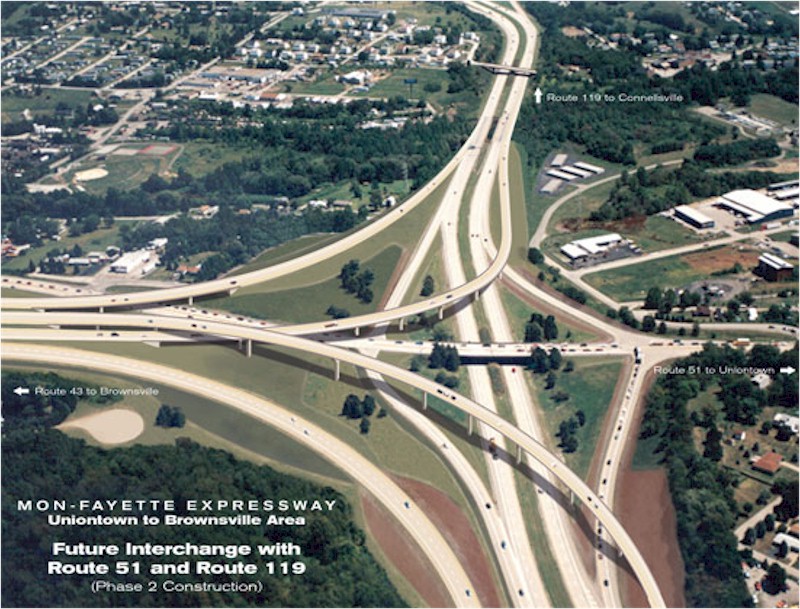
The Mon/Fayette
Expressway, Uniontown to Brownsville Project, will close the 17-mile gap
in the Mon/Fayette system between the
Brownsville to I-70 section
and the Uniontown to Fairchance section, both of which are currently in
operation. The completion of the Uniontown to Brownsville project in
conjunction with the portion of the expressway south of the Pennsylvania
border (currently being designed and constructed by the West Virginia
Department of Transportation, Division of Highways, WVDOH) will provide a
continuous 57-mile stretch of highway between I-68 in West Virginia and PA
Route 51 in Jefferson Borough, Allegheny County, 18 miles north of I-70 in
Washington County, PA.
The
purpose of the Mon/Fayette Expressway Uniontown to Brownsville Project is
to provide for safer and more efficient vehicular travel by improving
access, addressing future capacity requirements and drawing traffic
(especially trucks) off U.S. Route 40 and onto a more modern facility. The
project also is designed to support the efforts of the
National
Road
Heritage
Park, to make Route
40 less of a major transportation artery and more of a local traffic
corridor and tourist destination.
Introduction
The Mon/Fayette Expressway, Uniontown to Brownsville Project is one
of four Mon/Fayette Transportation Projects being undertaken by the
Pennsylvania Turnpike Commission (PTC) in southwestern Pennsylvania. The
West Virginia Department of Transportation, Division of Highways, (WVDOH)
is designing and constructing another section of the expressway south of
the Pennsylvania border. Two other sections were completed by the
Pennsylvania Department of Transportation (PENNDOT). The Brownsville to
I-70 section has been turned over to the PTC for operation. The Fairchance
to Uniontown section is currently operated by PENNDOT as a non-tolled
road. When all of the Mon/Fayette Expressway projects are completed there
will be over 70 miles of continuous limited access highway connecting I-68
west of Morgantown, West Virginia, to the Parkway East (I-376) at
Monroeville and Pittsburgh. These Mon/Fayette Transportation Projects are
in various stages of engineering design and construction as indicated on
the Map Legend. All environmental studies have been completed. The
following sections describe the project design process.
Environmental Study Phase
The preliminary engineering and environmental studies for the
Mon/Fayette Expressway Uniontown to Brownsville project were performed by
the team of Benatec Associates/Skelly & Loy, Inc./CHRS, Inc. for the
Pennsylvania Turnpike Commission. The Final Environmental Impact Statement
(FEIS) was distributed in July 2000. The Record of Decision (ROD), which
documents the North Alternative as the Selected Alternative, was signed by
the Federal Highway Administration in October 2000, thus authorizing the
PTC to proceed with the pre-final and final design, and construction of
this 17 mile section of the expressway. A presentation of Aerial
Photographs of the Selected Alternative that has been advanced to Final
Design and Construction may be viewed in the
Aerial
Photos of Selected Alternative section of this Web site.
Pre-Final Design Phase
The pre-final design phase was completed in the summer of 2003. The
purpose of the pre-final design phase was to refine the Selected (North)
Alternative to further minimize impacts to environmental features
(farmlands, wetlands, streams, parks and recreation areas and
cultural/historical resources), improve safety and operations of the
expressway, to reduce construction costs, and to prepare the project for
final design.
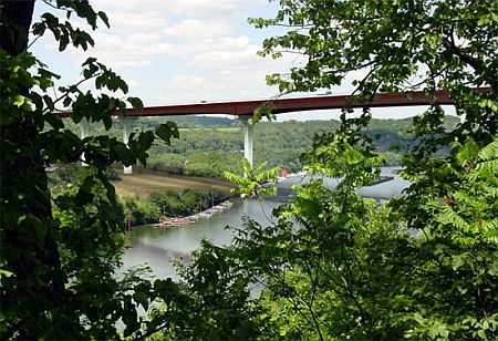
The pre-final design phase included studies for the proposed bridge
carrying the expressway over the Monongahela River (An artist’s conception
of the bridge may be viewed in the
Rendering of the Proposed Monongahela River Bridge section
of this Web site) and the preparation of a total take right-of-way plan to
initiate early acquisition of properties that are clearly required in
their entirety to construct the proposed expressway. The total take
right-of-way plan was completed by the firm of DMJM Harris, Inc. and
acquisition of these total take properties (56) has been completed.
For the pre-final design phase the project was divided into four (4)
pre-final design roadway sections and one (1) pre-final design Monongahela
River Bridge section. The culmination of the pre-final design phase was a
series of four (4) Design Field View Meetings with PENNDOT and the FHWA,
giving the PTC approval to proceed to the final design phase, initiate the
preparation of the partial take right-of-way plans as the required
right-of-way lines are finalized, to obtain the appropriate environmental
permits, coordinate with the utility companies to determine necessary
utility relocations, and to prepare the project for construction. The four
(4) Design Field View Meetings for this project were held from January
2003 through August 2003 and then after these meetings the PTC was
authorized to initiate the final design.
Public Meetings
Subsequent to the completion of the pre-final design and the Design
Field View Meetings, Open-House Meetings for the Mon/Fayette Expressway
Uniontown to Brownsville project were held on January 14, 2004 at the
Menallen School and on January 15, 2004 at the Brownsville High School.
The meetings were advertised in local newspapers and open to the
public. The primary purpose of the meetings was to provide information to
property owners that are affected by the Uniontown to Brownsville project.
Each affected property owner received an invitation and was provided the
opportunity to attend either meeting.
Representatives of the PTC, their right-of-way acquisition
consultants, and final design consultants were available to provide the
most updated information on schedules, the effect on individual
properties, the right-of-way acquisition process, and to answer questions
on the expressway project.
Final Design Phase
For final design and construction, the project was divided into 11
roadway construction sections, one (1) Monongahela River Bridge
construction section, a PTC maintenance facility construction section and
a mainline toll facility construction section (See
Detailed Overview Map [PDF:
1.69MB] for design/construction section designations).
The final design phase includes the development of final
right-of-way plans for acquisition of additional total takes not included
in the total take right-of-way plan and all partial takes and easements
required to construct the expressway. Final design also includes the
finalization of the roadway and structure construction details, obtaining
the necessary environmental permits, development of utility relocation
plans and the development of final construction plans and specifications
for bidding of each construction section.
Due to funding limitations the project was divided into Phase 1 and
Phase 2. (See
Phase1 / Phase 2 Overview Map
[PDF:2.4MB]) for limits of Phase 1 and Phase
2.
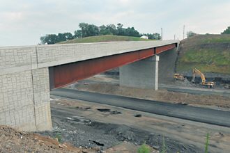
Phase 1 (approximately 9 miles of expressway) consists of Sections
51A2, 51B, 51C, 51D, 51E1 and 51N (PTC Mainline Toll Facility). Phase 1
includes construction of the eastern portion of the Expressway from the
Brownsville Connector (Redstone Way) Interchange to the Route 51 Connector
(Northgate Highway – S.R. 4039) Interchange which will provide access to
Routes 40, 51 and 119 near Uniontown.
Phase 2 (approximately 8 miles of expressway) consists of Sections
51A1, 51E2, 51F, 51G, 51H, 51J and 51M (PTC Maintenance Facility). Phase 2
includes construction of the western portion of the Expressway from the
Rte. 40/Toll 43 Cloverleaf Interchange in Centerville Borough, Washington
County, to the Brownsville Connector/Redstone Way Interchange in Redstone
Township. Phase 2 also includes completion of the Expressway/Route 119
interchange at the eastern end of the project, in Section 51A1.
The Final Design incorporated several features as modifications or
improvements during the pre-final design phase. These were shown to the
public at the January 2004 public meetings. These features are identified
as follows: